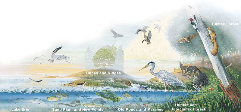
The Nature of Presque Isle
There are six distinct ecological zones on Presque Isle, each with a specialized plant and animal community. The record of geological succession can be traced through each of these zones. The zones include:
- Lake Erie, the Bay, and shoreline
- Sand plain and new ponds
- Dunes and ridges
- Old ponds and marshes
- Thicket and sub-climax forest
- Climax forest
Because of the diversity of ecological zones at Presque Isle State Park, many different species of plants and wildlife inhabit the park from the shoreline to the climax forest. Of all the plants and animals on Presque Isle, birds are the most studied and understood. The peninsula's location along the Atlantic Flyway and the diversity of natural habitats make Presque Isle State Park a haven for birdlife. Migrating birds, including several species of special concern, rest, feed, and nest here.
More than 339 species of birds have been recorded on Presque Isle, including 47 species of special concern. In cooperation with Penn State Behrend, the Tom Ridge Environmental Center has launched the Natural History Museum Dynamic Dunes. The seven collections in Dynamic Dunes contain more than 3,800 records of species collected in northwestern Pennsylvania. The collections provide a resource for scientific studies of the ecology of the region and provide a record of the area's biodiversity.
Birding
Presque Isle State Park has been rated by BirdWatching magazine as one of the top birding spots in the country. Presque Isle's location on the Atlantic Flyway makes it a favorite spot for birds to stop to feed and rest on their migration across Lake Erie:
- Waterfowl migration occurs during March and during late November through December
- Shorebird migration peaks during April and during September
- Warbler migration is observed during mid-May and during September
More than 339 species of birds have been identified on the peninsula. A bird checklist is available at the Tom Ridge Environmental Center in the Nature Shop.
A Migrating Peninsula
Geologists believe that, 11,000 years ago, Erie was under a giant sheet of ice called a continental glacier. As the glacier melted and retreated north, rocks, pebbles, and sand fell off, creating a ridge called a "moraine." So much ice melted that the valley to the north of Erie became a lake. The waves of newly created Lake Erie deposited sand on the moraine and created Presque Isle.
Presque Isle is a great location to see longshore drift in action. Wave by wave, eastward-moving wind pushes water and sediments. The accompanying forces of erosion and deposition continually shape Presque Isle's eastward migrating coast. This action greatly impacts the beaches and interior lands. When Presque Isle first formed, it probably was about three miles to the west.
The French name Presque Isle means "almost an island." The park area has been a real island several times. Storm waves have broken through the neck to isolate the main section of the spit at least four times since 1819.
A number of shoreline management techniques dating to the 1800s have been used to compensate for the loss of beach sand and serve to protect the park. Since 1819, the U.S. Army Corps of Engineers has attempted to control erosion at Presque Isle and has successfully closed a number of breaches in the neck of the peninsula caused by storms.
Efforts to control beach erosion now consist of a combined thrust of 58 breakwaters and beach nourishment. Breakwaters slow erosion by partially blocking the waves, reducing wave energy.
Weakened waves drop sand, which results in less sand carried along the shoreline and a "building out" of the beaches. The breakwaters have reduced the huge volumes of sand required to nourish the beaches.
Detailed information about the geology of Presque Isle is available from the Trail of Geology - Presque Isle State Park Guide.
Gull Point: A Fragile Ecosystem
The most ecologically dynamic area on Presque Isle -- Gull Point -- harbors some of the best examples of ecological succession in the park. This dynamic area, however, is also the most fragile. Many of Gull Point's plant species are threatened or endangered in Pennsylvania.
Jutting out into Lake Erie, Gull Point offers a safe haven and resting spot for migrating and nesting birds. Shorebirds migrate yearly from beyond the Arctic Circle to the southern reaches of South America and back again.
To preserve the resources of this area, the easternmost portion of Gull Point has been set aside as a State Park Natural Area for rare and migratory shorebirds to rest, feed, and possibly nest.
This natural area is closed to all public use from April 1 through November 30. Visitors can view this area from an observation platform reached via the Gull Point Hiking Trail. Due to the ecological sensitivity of this area, please stay on the designated trail.
Seasonal Natural Attractions
- January to February -- Ice dunes form on Lake Erie; skiing and snowshoeing
- April to May -- Early spring migrants and shorebirds; osprey and bald eagle sighted during migration (May); peak of warbler migration
- June to July -- Summer wildflowers; shorebird migration begins; aquatic wildflowers in bloom
- August -- Summer wildflowers in great abundance; young herons seen in lagoons
- September -- Fall warbler migration through month; bird banding; osprey and bald eagle often sighted
- October -- Waterfowl migration; monarch butterfly migration; foliage best in second week
- December -- Christmas Bird Count within 10 days of Christmas
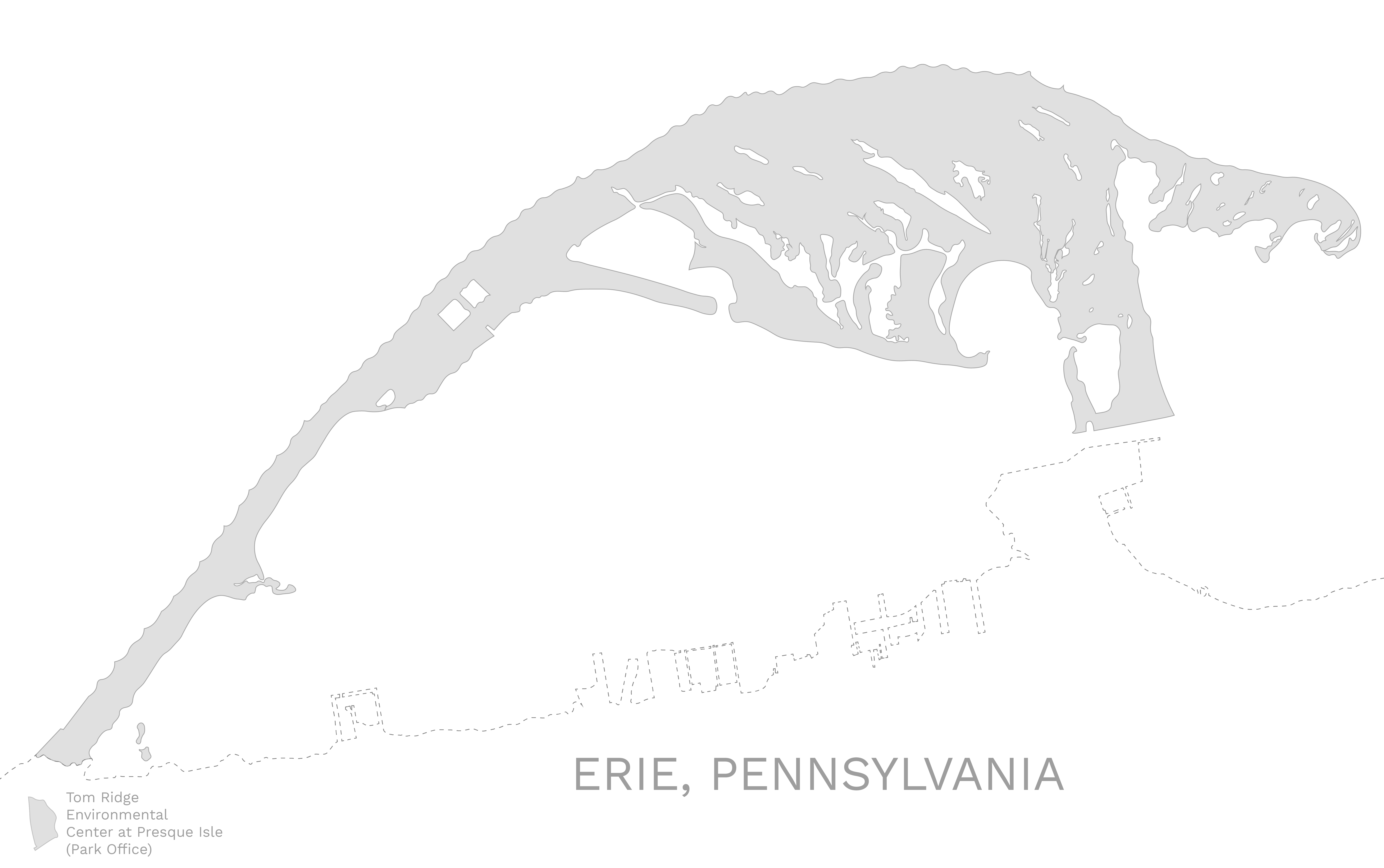
Map